This first sub history page and the following maps page
present the evidence still remaining today of Portmeirion's past. As the pages continue, a
more pictorial approach is used, with images of the old site, before Portmeirion was
created, with others showing the gradual development of the resort. The copyright in
pictures from old postcards and also books published by Portmeirion remains with the
original owners.
The use of such images on this website is not intended to infringe any subsisting
rights and due acknowledgement plus grateful thanks are given to: Robin Llywelyn and
Portmeirion, Judges Ltd., W. Harwood, Photo Precision Ltd., Harvey Barton and Son Ltd.,
The Photographic Co. Ltd., F. Frith and Co. Ltd., Valentine and Sons Ltd., J. Salmon Ltd.
and Phil Kendrick (also for his extensive knowledge and input) and Multimaps (see link
below). Additional thanks are expressed to the National Library of Wales for provision of
maps. The photos below were taken by this website's author and are © 2002. No
reproduction of this site's material is authorised.
|
|
|
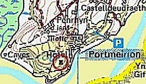
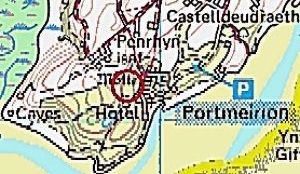
The first above map shows the location of the ancient Castell Deudraeth c.1185.
According to available data, observations taken on the ground on the Portmeirion
peninsula, topographical records and place name indications, the original location of the
mediaeval structure was as shown above. Its location was mentioned by Giraldus Cambrensis
('Gerald of Wales'), who was born in Pembrokeshire c. 1145. He wrote in 1188 (as
translated) "We crossed the Traeth Mawr and the Traeth Bychan. These are two arms of
the sea, one large and one small. Two stone castles have been built there recently. The
one called Deudraeth belongs to the sons of Cynan and is situated in the Eifionydd
area".
He referred to the second castle as being on the Lleyn peninsula "on the other
side of the river". Above the red circle where the ancient castle site is marked, the
other site, marked 'motte', shows the closer location, which Clough Williams-Ellis
described on his bell tower plaque as being "150 yards to the west". At the top
of both maps the name Castell Deudraeth refers to the present day, modern castellated
mansion, which was built mid 19th century. When comparing several other early maps on the
History 1 page, it will be seen where the cottage White Horses is situated, hence the
earlier name for it, "Tan-y-Castell", meaning 'below the castle'.
|
|
|
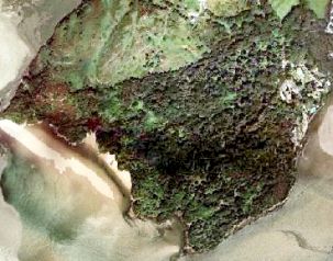
Portmeirion's peninsula, with bottom tip pointing south. The village can be seen
mid-right edge. The area behind Portmeirion has no Exotic tree planting.
|
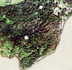
Same view, closer in, the upper white dot is the 'motte' position, while the
lower one is the ancient castle spot. These overhead shots are © www.multimaps.com
|
|
|
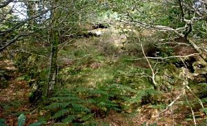
Hilltop site of the ancient Castell Deudraeth (see Home Page commentary). This and
the structure pictured opposite is unconnected with the present day Castell Deudraeth,
situated a kilometre away. The point in the above photo is reached from
Portmeirion's woods, being the highest position on a hill behind the largest lake. At the
opposite end to the Chinese bridge is a path to the top elevation.
A claim was made once that a tower enabled a view across the bay to nearby Harlech
castle. This appears insupportable, owing to the presence of a large land mass on the
opposite side of the River Dwyryd, between the hilltop point and Harlech. Below the point,
on the coast, is the White Horses cottage, previously known as 'Tan-y-Castell' ('below the
castle').
|
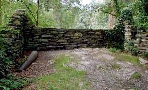
Three-sided walled erection referred
to as 'motte' or drawn on some charts. This curious three-sided structure has a cannon
barrel lying beside one wall. The location is adjacent to the 1983 Gazebo (created to
celebrate the centenary of the birth of Sir Clough Williams-Ellis). A recent survey
concluded that the building work was pre-1930s, but not thought to be of significance.
Possibly this was assembled in Sir Clough Williams-Ellis' time, after removal of what had
previously stood there.
There is an inscription on the bell tower describing 'ruins' located '150 yards to
the west' of it. The story is more fully told on this site's Home Page, but inclusion of
this structure is to allow consideration of it in relation to all other known past records
and events.
|
|
|
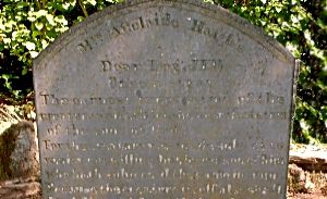
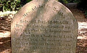
Remains not of Mrs. Adelaide Haigh, but of two of her
beloved pet dogs. She had them buried in the woods, 'The Gwyllt', behind her Aber Iâ
home. Their gravestones remain there to this day, now with others, in Portmeirion's
'Dogs' Cemetery'. Mrs Haigh lived in her mansion from 1870 until her death in 1917. See
also this site's Home Page as to the further development of the site by her son Caton
Haigh.
|