PORTMEIRION HISTORY2

History sub page 1
History sub page 3
History main page

PORTMEIRION 100 YEAR JOURNEY BOOK


Map-d.jpg (54261 bytes)


1819 Ordnance Survey surveyor's drawing (National Library of Wales). This appears to show the old Castell Deudraeth still existing as a structure of some sort. The position of this building, or its remains, appears further inland, at the back of Portmeirion's layout today. This would suggest a location matching the 'motte' site, referred to on the preceding History Main Page. Wherever the castle stood (and whether or not the 'motte' was the 12th century castle's remains), and whether some later structure was built (such as a tower, which was demolished in 1869) are questions which cannot be conclusively answered. This website allows consideration and presents a few pointers.

There is reference to a painting of whatever once remained at the time Portmeirion was about to come into being. However, those who manage the resort today are unaware of any such painting. Possibly an error was made, long ago, in mistaking a picture of the modern Castell Deudraeth. Alternatively, perhaps the painting perished in Portmeirion's 1981 hotel fire. This website considers whether there were different structures at different times: the famed castle which once overlooked the estuary; an early Victorian look-out tower, or folly, which fell into disrepair, or was demolished; the present-day representation of the 'motte', on a hill closely situated behind Portmeirion's village.

As for the 'motte', Sir Clough Williams-Ellis' inscription (on a plaque on the Bell Tower, for which stones from 150 yards away were re-used for its construction) appears to relate mistakenly to the original 12th century castle. The scale used in the above 1819 survey drawing would mean that the castle was of similar size to Harlech castle, shown across the bay (but not included in the section illustrated). No castle - certainly one of Harlech's size - could have fitted upon the hillock where the modern 'remains' (plus provided cannon barrel - see photo on History Main page) are standing today. For more enlightenment as to the castle's once location, more maps appear below.


Map-h.jpg (29991 bytes)


Map-f.jpg (23844 bytes)


1836 Admiralty chart, just before 'Aber Iâ'. The Foundry marked was called long ago 'Tan-y-Castell' ('below the castle'). See home page for fuller history and descriptions of people who resided on the peninsula.


This 1889 map (National Library of Wales) is the first to present merely a circle marking for a view point below the ancient castle position. By this time the foundry site showed a boat house and the 'Aber Iâ' mansion (note no 'motte' marked).


Map-e.jpg (91643 bytes)


A section of the Ordnance Survey 1838-1841 map (National Library of Wales) which is the last to present an approximation of a tower, or castle bailey. Some sources state that the stones of whatever remained there were used to build the new 'Aber Iâ' mansion. This has to be considered in the light of the structure later described by Clough Williams-Ellis as being "150 yards to the west"(of his bell tower),which was reportedly demolished in 1869. Therefore as Aber Iâ had already been built (1840s) the stones used for the bell tower could not be the same ones used for the mansion.

However, it it possible that this later structure was a tower on the 'motte' site and that its stones were indeed used to build the bell tower (as a plaque inside its base still attests) although they were never connected with the 12th century medieval castle, as Clough claimed. The positioning of the building marked 'Castell' might be thought not to match very precisely the position marked on the 1819 map (seen above). However, the scaling might not have been as accurate as that on later maps.


Map-g.gif (57830 bytes)


The 1901 Ordnance Survey map (National Library of Wales), shows the beginnings of the settlement above the 'Aber Iâ mansion, which was later developed to become the Portmeirion village. On this map the circular dot is easily seen as being located a long way from the 'village'. What was present there, to be worth marking upon the map, is no longer clear. Today there stands the remains of a 'Folly Cottage' (near Portmeirion's 'Ghost Garden') and behind the main hotel is a chimney shaped column (once a dovecote). However, these two small structures can be ignored, as can the three-sided stone walled enclosure, with its casually 'discarded' cannon barrel (see photo on History Main page). Once more, it can be seen that there is no 'motte' marked.


Map-a.jpg (35032 bytes)


In Sir Clough Williams-Ellis' early guide books the above map appeared. He marked the viewpoint, which was a long way from the drawn 'village'. No 'motte' was marked. The 'new' Castell Deudraeth is marked to the top right corner.


1928map3.jpg (63960 bytes)


Above is a June 1928 large map by Clough Williams-Ellis. It was originally reproduced in a guide book on two facing pages, marked "Port Merion. By CW-E. Map of lay-out.", with left and right 'halves' labelled. The "Gwilt (sic) Gardens" are marked and a "spring". More importantly the "Site of 12th Century Castle Deudraeth" appears along the top, drawn according to Clough. Below the hotel is a berthed boat, the "Amis Reunis" vessel (later a 'houseboat' providing added accommodation). The "Round House" to the left is the 'lighthouse'. Thanks to Phil Kendrick for providing a copy of this rare document.


Map-c.gif (78225 bytes)


Many years after the pre-war guide books, the above chart of Portmeirion was produced. The Gloriette was soon to be created (early 1960s), replacing the central tennis court . Now, at position 'B', the name 'Castle Rock' had been devised (marked to the right of the letter 'B'). This demonstrates best of all the measurement of 150 yards from the Bell Tower, as previously mentioned. The 'Folly Fort' was also added, at position D (beside the 'Ghost Garden'). The 'A' marking shows roughly where the ancient castle site was located, now being described as 'Supreme Viewpoint'. The 'C' position shows the 'White Horses' cottage, with its added 'Observatory Tower' (or 'Camera Obscura'). An old Gold Mine is marked in the middle of the chart. Scale measurements are not a feature. For avoidance of doubt, the letters A, B etc on maps on this page have been added by this website's creator.


Map-b.gif (67303 bytes)


A 1970s Ordnance Survey map showed the fully completed Portmeirion resort. This map even added the word 'Motte' (marked as position 'B', for the first time on a modern map), which corresponds to the chart above it and its 'Castle Rock' name. Meanwhile the circle marking, present on an OS map from 70 years earlier, is retained (and marked by an arrow here). Below is a current map, still showing the 'motte' (although in a recent survey no remains were identified) and view point. Over the following 9 pages, the more gentle pursuit of photographic browsing can be undertaken!


Map-i.jpg (29909 bytes)


Large scale recent OS map, with latitude and longitude markings. However, plotting the claimed position of the 1914 Ancient Monuments report (lat 52° 55m 8s N; long 4° 5m 15s W) seems to arrive at a point far away from Portmeirion. Either the 1914 record is incorrect, or it has been subsequently wrongly noted, or the navigational methods have changed in later years, or this website creator is deficient in map reading skills! It also appears that on no official maps (all reproduced above) has there ever been any marked site reference to an 'ancient' or 'medieval' or '12th century' castle.


Potted History and General Jottings


Aber Iâ in Merionethshire was a small settlement with a building (later called 
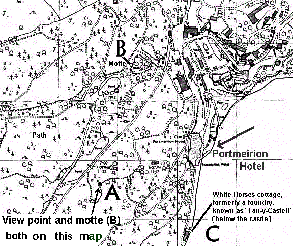
White Horses cottage ) built early in the 1830s as a small foundry. A Mansion was built there around 1850, for Henry Seymour Westmacott, who died in 1861. Then Sir William Fothergill-Cook lived there and then from the 1880s Mrs. Adelaide Haigh and her family.
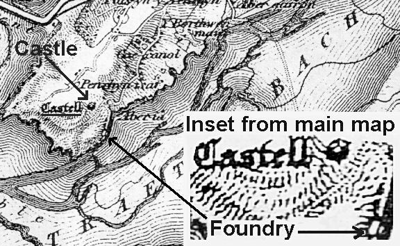
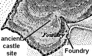
In about 1850 the walls of the previous Castell and all but 10 feet of the tower were knocked down. The stones were moved a short distance and reused in building the outer walls of a larger new 
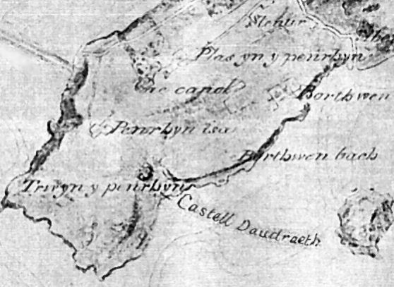
house, probably the mansion. The original, medieval Castle Deudraeth was built around 1186 by Prince Gruffydd and Prince Maredudd ap Cynan. Situated on a plateau 70 feet in diameter, it was basically a hill fort comprising a stone walled enclosure with small wooden buildings and a stone tower nearly 30 feet high. From this and another castle the two brothers ruled a large area of North West Wales. They died in 1200 and 1212 respectively. Further owners maintained the Deudraeth castle including Red Gwain, causing the structure to become called locally Castell Gwain Goch. In 1699 Parish records show it to be called Castell Aber yâu.

Aber yâu meant rivermouth yoke suggesting a joining together with the neighbouring River Glaslyn estuary and the River Dwyryd. This was the name in the 17th century but the name became corrupted a century or so later to Aber Ia meaning rivermouth ice or frozen estuary or frozen mouth.

The name Portmeirion was adopted in 1925. Meirion was a grandson of the chieftain Cunedda who conquered North Wales early in the 5th century.
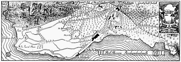
Traeth Bach means with the words transposed small beach. In the early 1800s the area now the hotel terrace boasted a small hamlet of several cottages. Building of a few wooden ships occurred in 
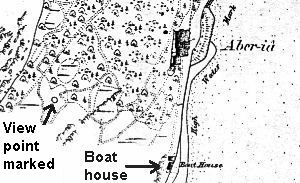
1830s, the largest being the "Progress" of 1834, used in the slate trade.

The new Castell Deudraeth was built in the 1840s as the private residence of David (Dafydd) Williams, solicitor and local MP, being Clough Williams-Ellis' great uncle. In fact, Williams’ elder son Sir A. Osmond Williams MP was the person who asked Clough if he knew of anyone interested in renting or acquiring his other estate, being the next door Aber Iâ. The nephew investigated the property in 1925 and bought it immediately. Within a decade, he had purchased the adjoining Deudraeth estate bringing for the first time the two estates into one ownership.

The first maps to use the name Portmeirion were in the 1930s prepared by the German forces in preparation for their planned invasion. It was not until 1947 that the OS maps used the name when mapping the Dolgellau area.

Clough Williams-Ellis bought the Aber Iâ estate measuring about two thirds of a mile wide and 200 yards deep (not then including the woods, Y Gwyllt). Clough paid £4,000 and in subsequent years was able to buy lands bordering his acquisition (1931 the Deudraeth estate and then 1941 the two properties formerly owned by Caton Haigh. One of these was Cae Canol (middle field) and the other being the Y Gwyllt, 'the Wilds').

The Mansion and Mermaid (the gardener's cottage then), was completed about 1850 for the first tenant at Aber Iâ being Henry Seymour Westmacott who died in 1861. Then Captain William Fothergill Cooke (his surname sometimes being hyphenated and sometimes the last word being spelled 'Cook'), was the second tenant and he and Westmacott spent large sums on ambitious plantings. In 1879 Cooke died and then Mrs. Adelaide Haigh was the tenant. She lived there with her two sons and three daughters and they had a caretaker, a housemaid and a kitchen maid. She would not allow growing vegetation or plants to be cut and so the place became gradually a wilderness. She was around 85 years old when she died in 1917. The last tenant in the early 1920s was somebody who then vanished. The estate owner, Sir A. Osmond Williams, then allowed Clough to acquire it. The adjoining estate was then under the control of Caton Haigh who became a great authority on flowering shrubs. Soon after 1926 The Angel and Neptune cottages were built to add extra accommodation.

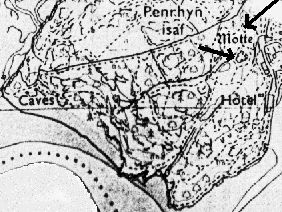
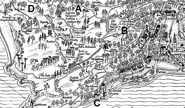
It has been claimed that access to the Castell Deudraeth on the rock by the centenary gazebo was by a bridge of nearly 30 feet long over a deep ditch and that it had a semi-circular tower (a Keep) of 10-12 feet in diameter and 30 feet in height.

Around the time of the medieval castle, there ruled in 1188 Princes Gruffydd and Maredudd, grandsons of Owain Gwynedd. For the next 600 years the castle was either deserted or owned by a succession of unknown people, one of whom was Red Gwain. This led to the place becoming called Castell Gwain Goch for two or three hundred years.

In 1699 the name applied was Castell Aber yâu. In about 1800 a small hamlet existed and became known as Aber Iâ. The area became owned by John Cartwright and then Captain John James Barton, who died around 1850, after which David Williams bought the land and leased it to H.S. Westmacott. He all but demolished the castle keep leaving just 10 feet standing and plundered the walls as well. Around two years later his mansion and two outbuildings were completed but he died a few years later in 1861. Then William Fothergill Cooke in about 1869 (after David Williams died) knocked the 'castle' down, to discourage potential visitors. 20 years later Mrs. Haigh and her family resided there.

By 1861 Westmacott had created a "sophisticated private paradise" with a marine residence and 27 acres of "pleasure grounds". All of the works were executed without regard to cost. When H.S. Westmacott died there was an auction of all his furniture and other property described as "magnificent assemblage" in 1861.

The 1891 census showed Mrs. Haigh as having her two sons, three daughters and three servants living there. It appears that prior to their living there it was a second home to somebody because there were no residents locally recorded. George Haigh was the head of the family age 30, Adelaide E.J. Haigh was his mother age 60 and son Claude and daughters G.A. and S.H.R. but full names not known.